GeoDecisions Notify on Agenda during Ohio Water Workshop

Ohio Water Workshop

Technical Architect, Adam Conner, discussed how GeoDecisions Notify helps water utilities deliver more than 120,000 phone, email, or text messages to customers per hour. Built on the Esri® platform, GeoDecisions Notify integrates business-specific workflows.

Thank you to Muni-Link and Ohio Rural Water Association for this partnership opportunity!


Esri DevSummit: Plenary Powerhouse and Keynote Legend

GeoDecisions’ Esri® Developer Summit (DevSummit) team members, Shankar Lakshmanan and Quinn Huber, described their DevSummit experiences from useful technology updates to engaging keynote addresses. 

Douglas Crockford presentation

Shankar witnessed new and upcoming GIS technology innovations under development at Esri, including significant improvements to existing tools to develop robust and responsive map applications. Read more.

Quinn enjoyed listening to accomplished author Douglas Crockford, considered a JavaScript expert by the community, who developed the data format JSON (JavaScript Object Notation) - projected to overtake XML this year. Read more.

Esri FedGIS: Technology Takeaways and Abundant GIS Solutions

Flying Drone

GeoDecisions’ Esri® Federal GIS (FedGIS) team wrote about their information-packed experiences during the Esri FedGIS, from data and analytics to plentiful GIS solutions and technology takeaways.

Kevin Switala, GISP, highlighted Web GIS as a transformational architecture and described the Esri® vision of geospatial technology using the terms “Data-Analytics-Action.” Read more.

Hany Hassaballa, EIT, GISP, learned useful tips for configuring Esri solutions through a variety of workshops geared toward user experiences and developers. Read more.

Jim Lawruk summarized his three-day experience in five major event takeaways. Read more.

GeoDecisions Helps PennDOT Handle 275 Million Traffic Records Per Month

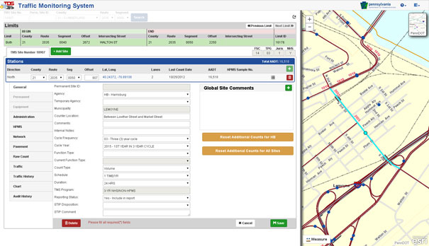
(Harrisburg, Pa.) GeoDecisions, an information technology company specializing in geospatial solutions, developed a new traffic data system (TDS) that processes more than 275 million new records per month for the Pennsylvania Department of Transportation (PennDOT). Built on the Esri® platform, the TDS helps PennDOT’s Bureau of Planning and Research better manage the download of traffic data from collection sites throughout the commonwealth of Pennsylvania.

“Built to Federal Highway Administration standards, GeoDecisions’ redesign of our TDS provides us a method to seamlessly introduce new counting devices, more efficiently verify our raw traffic data, and speed up our process for creating yearly traffic volume maps,” said Andrea Bahoric, planning division manager with PennDOT.

The new TDS improves PennDOT supervision of 45,000 short-term or portable counters that classify vehicles, record traffic volume and weight, and determine driving speed. The system’s mobile Field Operations Module (FOM) also streamlines in-pavement counter inventory and maintenance activities.

“FOM enables PennDOT field technicians to use smartphones or tablets to perform site reviews and document issues,” said Greg Ulp, senior project manager with GeoDecisions. “Convenience and efficiency are critical factors when enhancing technology and managing assets.”

PennDOT’s predecessor traffic data management system contained nine applications with dated technology requiring manual intervention to collect and verify information. GeoDecisions’ TDS redesign features five modules streamlined for better performance and usability. The new automated system includes remote user access and cutting-edge geographic information system (GIS) mapping, web service, database, and coding technologies.

“Our transportation system solutions provide a proven business model for analytics, reporting, reliability, and technology workflow management, “said Tom Saltzer, vice president of government delivery with GeoDecisions. “PennDOT’s redesigned TDS is a long-term collection, verification, and geospatial solution that reflects their ongoing enterprise GIS investment strategy.”

Taffic Monitoring System

GeoDecisions’ experienced staff of professional consultants, analysts, and developers support clients worldwide. Fundamental to the company’s award-winning approach is the integration of spatial information to empower existing systems and processes. GeoDecisions’ philosophy is based on an enterprisewide approach to the integration of diverse information technologies, data formats, and systems. We are proud to be an Esri Gold-tier Business Partner and ISO 9001:2008 Certified.

GeoDecisions Featured in Insights Success Most Valuable Tech Companies Edition

(Harrisburg, Pa.) Embarking on its 30th year in operation, GeoDecisions, an information technology (IT) company specializing in geographic information system (GIS) solutions, was recognized in the December 2015 edition of Insights Success.

Insights Success

In an article titled, “Smart Geospatial Solutions for Your Enterprise Business Destination,” the magazine describes how GeoDecisions helps logistics and fleet management, insurance and financial, municipal management, public safety, transportation, and utility clients make more informed decisions.

GeoDecisions President Brendan Wesdock

GeoDecisions President
Brendan Wesdock

“GeoDecisions emphasizes customer service - evident in the fact that more than 90% of our business is generated from annual repeat customers,” said Brendan Wesdock, MCP, GISP, president of GeoDecisions. “We define our success by our customer’s success.”

Partnering with industry leaders such as Esri®, GeoDecisions provides organizations with a full-cycle of geospatial IT service, from strategic planning and implementation design through system integration and testing. The Insights Success article highlights GeoDecisions’ success through the years and strides in innovation.

Read Wesdock’s blog, titled “Our Promising Path Forward,” for more information.

Since 1986, GeoDecisions’ team of spatial IT experts has been developing award-winning, innovative solutions. The company helps clients throughout the U.S. and across the globe improve their business and increase productivity. An Esri Gold-tier Business Partner and ISO 9001:2008 Certified, GeoDecisions pushes the boundaries of GIS by creating new applications, evolving existing systems, and revolutionizing the way organizations accomplish their work. #GeoDecisions30