Learn How Your Design Process Can Improve with GIS
/As a division of Gannett Fleming, GeoDecisions has been deeply rooted in the architecture, engineering, and construction (AEC) world since its inception. With a century of experience and offices worldwide, Gannett Fleming is a trusted international infrastructure firm with expertise in planning, design, technology, and construction management services. Our geographic information system (GIS) expertise has supported the advances of many of Gannett Fleming's infrastructure projects in all those areas except one – design. But times are changing, and GIS is becoming an intricate part of the design lifecycle.
Developing a BIM and GIS Partnership
Thanks to the partnership of Esri® and Autodesk® in November 2017, we could begin to integrate our GIS expertise directly with the design process of our Gannett Fleming engineers and architects. We have heard the challenges they and their peers encounter to deliver designs and as-built designs to clients. There are struggles to help clients understand the models, make modifications with minimal costs, and avoid flaws in the plan before construction.
GeoDecisions is uniquely positioned to understand the relationship of the Autodesk and Esri collaboration to support the needs of the AEC firm. Besides being part of one of the oldest AEC firms, we are Platinum Partners with Esri, the highest partnership available. There are fewer than 20 Platinum Partners in the world, and we believe our partnership provides us with a greater source of support and understanding for Esri technology from which our partners can benefit. We are also a strategic partner with Autodesk. Again, we are only one of a few AEC firms in the industry to hold this partnership, which provides us with a rich relationship with Autodesk that benefits our clients. Additionally, our firm's representatives sit on the Esri-Autodesk Joint Customer Council, working hard to advance the solutions necessary to make this partnership a success.
Autodesk builds 3D design, engineering, and construction software. Esri is the global market leader in geographic information system (GIS) software, offering the most powerful mapping and spatial analytics technology.
Before the Esri-Autodesk partnership, GIS and BIM were seen as separate, maybe even competing systems. Their story is still evolving, but the two are more complementary now, where GIS supports operations and analysis while BIM provides design. Building bridges and other structures does not happen in a vacuum. Their designs will interact with the world around them, other buildings, walkways, and roads. Also, clients need to be involved along the way, and GIS technology is a proven platform for collaboration. Bringing GIS and BIM together supports an entire lifecycle.
“By providing a real-world context of an asset’s existing environment within which designers and engineers can explore and evaluate design and construction – GIS informs BIM. Then, rich and more accurate models can be utilized to improve the overall operations and maintenance of assets within a larger area – in this way, BIM fuels GIS.”
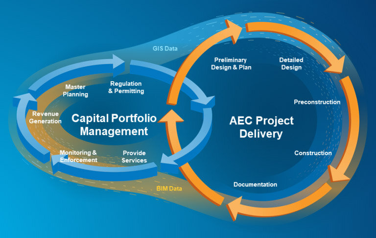
The purpose of BIM-GIS integration is to enable the workflows for building assets and for managing them. There are not discrete, well-defined hand-offs between these two workflows. Courtesy of Esri
Creating Enhanced Visibility
Often in life, you are told to listen to both sides and get the whole story before making decisions. That is what is happening with the GIS and BIM integration. Designers and clients are getting the entire story. Gathering data from different departments to analyze no longer takes hours, days, and weeks, but minutes. Adding real-world geography improves decision making, planning, and permitting phases, which involves assessing social, economic, and environmental impacts – all areas that could slow down or halt projects.
By placing the model in its actual location, clients and designers can understand the design in ways not previously achieved with BIM alone. Christian Birch, Engineering Technology & Innovation Senior Manager of Gannett Fleming, said, "With BIM and GIS, we enable the opportunity for a digital twin.” A digital twin is a digital replica of a physical object or system. With a digital twin, we have the possibility of analyzing data and monitoring systems to head off problems before they even occur.
All of this leads to better value for our clients. Improved understanding of the designs and modifications and their impact on the surrounding environment increases client satisfaction and decreases costs for changes because something was misunderstood.
Feeding the Lifecycle with Data
Going back to Esri's lifecycle diagram, one of the biggest challenges we face is educating clients and designers on the data life cycle's importance. With GIS, the information flow does not just end when a building or road is completed. More data can be gathered, feeding the capital portfolio management and the AEC project delivery side.
Internal processes can be improved, and future designs can become more streamlined, efficient, and cost-effective thanks to the data. The key is to get people on all sides to see the importance of that lifecycle and not just stop when their part is completed or because funds are depleted.
Bridging the Remaining Gaps
Progress has been made, but this synergy of two disciplines – GIS and BIM – is still in its infancy. Esri and Autodesk are diligently working to improve the ease with which the data moves between the technologies. Brian Smith, Senior Vice President of GeoDecisions, states, "As partners of both AutoDesk and Esri, and part of the Esri-Autodesk Partnership Council, we believe strongly in the benefits of this integration and are working hard to help the continued collaboration and education of others on the benefits."


